Friday, May 13, 2016

Ingonish to Hunter Mountain Chalets

The last blog post took us from Sackville, New Brunswick to the Brown's at Margaree Centre and then to Ingonish.

Brace yourself as this is a long post including a lot of images, as it takes us from Ingonish all the way to Hunter Mountain covering some of the best parts of our trip on and off the Cabot Trail!

Our Chalet at Hunter Mountain Chalets
Speaking of images, remember to click on any image to view a larger version.

We traveled Tuesday from Ingonish to Pleasant Bay then Wednesday to Hunter Mountain and are currently at Hunter Mountain Chalets just off the southern portion of the Cabot Trail.  This is such a great place that we plan to stay for at least 3 days. We have had quite nice weather for the past couple of days and the weather guessers are promising more for the next day or two.
Sunrise at Hunter Mountain Chalets
But it is important to say that, in spite of the rain and cold for much of the time this has been a great trip because the area is mostly beautiful but also, to a large degree, because we have taken our time and let the trip evolve each day. Of course, we had to plan accommodation locations ahead, but we kept the daily driving distances short to allow lots of time to stop and walk a bit, take photos and just enjoy the scenery and some chats with local people.
The Entry drive way and Office at Hunter Mountain Chalets
One in particular will be remembered as being quite special.

On leaving Ingonish we stopped for gas at a small “full service” gas station, Caper Gas  Drive ‘er (this is not a spelling error!).
I commented to the person filling our tank, who was also the owner, that full service places are pretty rare. This initiated an interesting, informative and wide ranging conversation about the economic circumstances of not only gas stations but this part of Nova Scotia. For example, he said that to convert his business to self service would cost $150,000 which he cannot afford. He can barely stay open in this region where there are 2 profitable months, 2 or 3 iffy months and the rest profitless months!
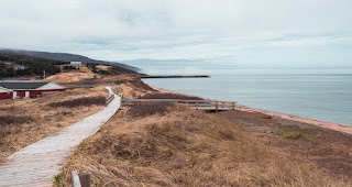
Along the Coastal Loop by Aspy Bay on route to Pleasant Bay
He can stay open because, having been here for decades his family does not have a mortgage to pay. Others are not so fortunate. There are few to no jobs so the young people leave and the population loss decreases even local demand seriously affecting the local economy. This poor economic condition shows in the deterioration of the provincial roads even on the “famous” Cabot Trail and this deterioration is emphasized in comparison to the excellent roads in the Cape Breton Highlands National Park, a federal jurisdiction.
Until the area can be rejuvenated by making it a year round economically sound environment things are not likely to improve. But our conversation was not all doom and gloom as he says some promising things are happening. He also gave us some excellent advice about how we could find the best routes and resources on and off the Cabot Trail.
Community of White Point near Scotch Cove
When we left our friend at his work we departed with a new perspective on the region. And armed with his excellent advice, we found the route and the scenery from Ingonish to Pleasant Bay which was by far the most spectacular to that point.
From Ingonish we traveled on the Cabot trail for about 10 kilometres along the coast to Neil’s Harbour where the Cabot Trail turned inland. Here, on the advice of our gas station friend, we turned off the Cabot trail onto a “scenic route”, the Coastal Loop, which took us to and along the coast of Aspy Bay to some spectacular scenery in an area where whales apparently travel and, with luck, might be seen. We were not that lucky.

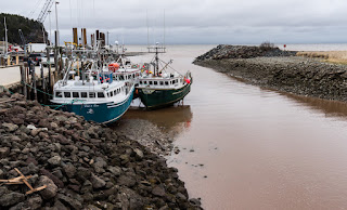
At White Point we went down to the wharf and had a chat with a couple of fisherman and asked about the large "baskets" we had seen stored along with lobster traps and wondered about their use. (See the photo of these large orange coloured baskets beside lobster traps in the last blog post) They explained that they are used to catch Snow Crabs in April. Several fishing boats were in the dock area apparently getting ready for lobster fishing which begins next Friday.
View from White Point with the "pointed" mountain marking
Cabot's Landing in the distance.
We considered going to Meat Cove, the most northerly point on Cape Breton but our friend, while partially supporting the idea had said that it was a 2 hour journey and not likely to provide more than we would see along the coast of Aspy Bay. After a lot of stopping and photo making, time tends to pass and we realized that we did not really have enough of it to go to Meat Cove. Our gas station travel consultant had also advised us to look across Aspy Bay from White Point and find a pointed mountain - “we say it looks like a breast” he said with a mildly embarrassed smile. “That, according to Nova Scotians, is the area where John Cabot first landed in North America.”
So, we decided to go in the direction of Meat Cove as far as Cabot landing at Sugarloaf to visit the general location of Cabot’s arrival. There appears to be some competition between Nova Scotia and Newfoundland on this event, each claiming the historic spot. When we arrived at Cabot's Landing Provincial Park, you guessed it - it was closed.
So, from there we retraced our “steps” back to the Cabot Trail and on to Pleasant Bay. Now, when we spotted our Pleasant Bay accommodations we gasped a bit at the overpowering array of pink and blue buildings and lamp posts and virtually everything paintable! Thankfully, the inside was spared the outdoor paint decor. Another definitely spartan space — a small room, a bed, tv set, one ceiling light (there were a couple of other lights on the wall but we were unable to find a way to turn them on), a small table and a bathroom. The only restaurant in Pleasant Bay was not open. We decided to stay only one night.
We set out fairly early on another overcast and cold morning to find a place for breakfast and with high hopes that our booking in Hunter Mountain would be more to our liking.
At the entrance back into Cape Breton Highlands National Park we found the visitors centre to be not exactly open but sufficiently open for us to pick up a topographical map, some books and a few other bits and bobs that we didn’t really need.

The very friendly park folks told us that in the beautiful town of ChĂ©ticamp just down the road we would find a Co-op grocery store, a liquor/wine store and an excellent breakfast at Evangeline’s Family Restaurant, and they were correct on all counts!
The rest of the drive to Hunter Mountain took us through more excellent scenery and back through the area of the Margaree’s - remember the Margarees? We passed them all and about 30 Km or so  later with some trepidation we prepared ourselves for the first view of Hunter Mountain Chalets. To our relief and delight what we found was a terrific place!

It was immediately apparent to both of us that we should stay here for more than one night. After we signed in the proprietor, Roland, said he would take us to our lodgings and provide an orientation and he did. There is a small kitchen and the living space and bedrooms are both spacious and welcoming. Roland, who is extremely friendly obviously cares deeply about this place.


His attention to detail is reflected in the quality of everything about the buildings and rooms from the excellent German designed windows to the European beds and the Van Gogh and Monet prints on the walls! - as well as the carefully laid out and marked walking paths on the extensive property! Roland carefully and thoroughly explained how everything works including the recycling arrangements, the history and nature of the walking trails as well as the controls of the TV and he actually set up the TV so we could watch the Jays game!
We have seen nothing even close to this. And at a price much less than we paid at substantially less appealing accommodations. Definitely a three day stay!

(I should tell you that, though I am talking about Hunter Mountain Chalets here, only the last photo has anything to do with Hunter Mountain. The others were made well before we reached here. It's not always easy to coordinate the text with the images that I want to include.)
We would like to stay longer but we should be in Truro by Saturday. So, on Saturday when we reluctantly leave this place, we will face a relatively long drive back to Sackville where we will stay one night before leaving on Sunday for the Gaspé.
Sunrise at Hunter Mountain Chalets

Thursday, May 12, 2016

Sackville, New Brunswick to Cape Breton


Saturday we left Sackville en route to Port Hawkesbury just over the Canso Causeway on Cape Breton Island.. But we planned to stop first in Truro, Nova Scotia where, we were told, we would be able to see the Tidal Bore. Some will know what the Tidal Bore is but some may not, so for the latter - the 
Small Tidal Bore wave - centre left.
Tidal Bore it is a wave of water running against the normal flow of water in channels, like rivers, which normally drain into the Bay of Fundy. The wave is created during the rising of the Bay’s huge tide which in some areas, at its peak, may reach as much as 12 to 14 meters. 
The rising tide waters push the river water up stream reversing the normal river flow and, where the channel is relatively narrow, the Bay water rushing inland can create a wave reaching as high as one meter. We were pretty keen to witness this awesome phenomenon so when we reached Truro we set out to find the place to see it. The tourist information folks would be able to direct us, we thought, but they were closed. So, in the process of trying to find where to go we asked someone in a local business and, fortunately he was the right
Old bridge supports before tide began to rise.

person. He said the city was reconstructing the area but had made little progress and the viewing there was not that good and, anyway, he said “the rushing bore is not an animal - it’s just a lot of water”. He was right about the place - it was a mess. So we decided to go down the road to Maitland where there was an interpretive centre so it might be better. In the end, we found the location and though the centre was closed and there was no one in sight, we were able to walk to the viewing area. We had looked up the schedule for the event and arrived about 30 minutes before the predicted time. The scheduled time came and went with nothing obvious happening in the muddy Shubanacadie River, the longest in Nova Scotia. For a change the weather was sunny and
Old bridge supports 90 minutes after tide began to rise.
warm so the waiting was not unpleasant. Just as we were considering giving up we saw a small wave quite a distance away in the shallow water on the far side of the river! Hard to tell the height of this wave because of the distance but my guess possibly 30 cm.  Though this was the only actual wave that we saw, it was obvious within 5 to 10 minutes that there was a great deal of water moving inland against the river flow, raising the water level quite rapidly, filling the previously bare edges of the river and moving up the sides of the old free standing bridge piers. . Though the “wave” was not high, the overall phenomenon is pretty amazing to see.  Still images won’t convey the speed of this rising tide but comparing a couple of images (above) before and about 90 minutes after the beginning showing a rise in water level of 3 to 4 meters later might help. In the first photo of the old bridge support the water is quite still but moving slowly to the left but in the second image the water is approaching the top of the bridge support and clearly moving rapidly to the right!
Time to move on as we would like to get to Port Hawkesbury in time to get settled and have an enjoyable pre Mothers’ Day dinner, which we did.
We left Port Hawkesbury on our way to the Ceilidh Driving Trail (pronounced Kaylee) around 9 am in dense fog which, thankfully, cleared within the first few kilometres.
Inverness Beach Trail
There is a parallel walking trail along the shore which we enjoyed for short bits along the way at Judique and Inverness Beach where we also had a bit of lunch.
Inverness Beach Trail
We reached the Cabot Trail early afternoon and shortly after checked in at our cabin at Margaree Centre, not to be confused with Margaree or Margaree Fork, East Margaree, Northeast Margaree nor Margaree Harbour - eight Margarees in all! 

Th place we stayed, “Browns -  Bruaich na H’Aibhne” Suites (by the Banks of the River), was a unique collection of pleasant but aging cabins along with several trailers converted to rental “cabins” scattered about a lovely piece of property. After one night at Brown’s we headed out for Ingonish and decided to go by the Native learning centre  “Wagmatcook, but it was closed.
Near the learning centre we happened on the Big Spruce Brewery in Nyanza and stopped by to sample their brew.

We tasted samples of the beer they had on tap and decided to buy a half growler (Yapper) of two of the four beers we sampled. One was a Pale Ale and the other a stout like beer which they call Cereal Killer! 

This photo made in their tasting/drinking room with an awesome view includes and image of the  samples of the four beers that they had on tap that day.
We then moved on to Baddeck where we picked up some groceries, had lunch and found yet another closed information centre. 
A bit here about the advantages and disadvantages of doing this trip in the “off season”.

Near Margaree
It’s great to miss the traffic and the crowds so that we can book accommodations as we go and be reasonably assured of finding a place. And that’s very attractive. The downside is that many points of interest and important resources, such as tourists information places, are closed. Fortunately, with regard to the latter, we have internet access and CAA books!


Too much rain has made getting out and about less than ideal and the temperatures have been on the cool side, not unexpectedly. And, as we knew from our two years in Nova Scotia years ago,  no leaves on deciduous trees until June! And the second characteristic about Nova Scotia of which I am now reminded is the wind which seems to blow vigorously and constantly. 
Lobster and Snow Crab traps

From Baddeck we drove north on route to Ingonish and our overnight at the Knotty Pine.  Now, like Margaree there is not just one Ingonish! We have Ingonish, Ingonish Ferry, Ingonish Harbour, Ingonish Beach and Ingonish Centre. Knotty Pines was in Ingonish Ferry on Ingonish Harbour. Several of the nearby bodies of water bear the Ingonish name - South Bay Ingonish, North Bay Ingonish, etc.
The Knotty Pine cabins are a bit closely, if not  precariously, perched above the shore of Ingonish Harbour (photo right) so our room offered a lovely unobstructed view of the harbour.

Near the Knotty Pines at the entry to the Cape Breton Highlands National Park we found their visitors centre to be open!.. well, not exactly as they don't officially open until May 20th. But they were extremely welcoming and we were able to pick up some very helpful maps and information about the area and the National Park and we were early enough to be free of any fees!

On Tuesday, May 10 after a fairly cramped night in our tiny room we left the Knotty Pine and Ingonish for our next destination at Pleasant Bay.

Friday, May 6, 2016

Beyond Saint John

Well, we spent most of the day en route to Sackville in the “clouds”, as it were. Little actual rain but lots of fog and mist and temperatures no higher than 9 C. But in spite of the weather it was an excellent day!

(Click on any photo so see a larger version)

The first leg of the days drive included a small detour of about 15 Kilometres to the community of Kingston to pick up some food for our dog, Kita. She is on a raw food diet so finding sources along the way and keeping it cold has been an interesting challenge of the trip. This short side trip turned out to be of special interest. First, it involved an unexpected ferry ride - little waiting time as the trip is short and there are two small craft constantly moving back and forth carrying up to about 15 vehicles - depending on size. The drive to the meat source took us on some interesting roads and past equally interesting houses. Our GPS guided us to the address and en route we found ourselves on Shampers Bluff Road.

To most this likely means nothing but others might know that the internationally known Canadian photographer, Freeman Patterson, lives on Shampers Bluff! In 2009, when I attended a Freeman Patterson workshop in St. Martins, New Brunswick, I spent a day at Freeman’s place which is on a very high piece of land with some amazing views of the water and land below.

After picking up Kita’s 5 days supply of food we drove past Freeman’s place, but decided not to pay him a visit. This photo from the road is a view of the area near his place. It is worth noting at this point that photos of places like this - which look quite spectacular - rarely do any justice to what the eye and brain perceive.
Back to the ferry and on toward our destination for the day, Sackville, New Brunswick, a drive of around 200 Kilometres. About two thirds of the way we decided to leave the highway and travel down to the Bay of Fundy coast along a secondary road thinking we would be very close to the water, and we were but only glimpsed it at infrequent intervals. The drive took us through Fundy National Park which is quite spectacular though we saw it only from the road as everything is closed until mid May. Even so, we past some very interesting terrain and places of interest, like
Overlook in Fundy National Park
some unusual colourful hillsides and the small village of Alma, which is just outside the National park and right on the water’s edge. 
Village of Alma

The tide was out so any boats at the dock were left stranded on the ground waiting for the next high tide. And Ruth found a general store where she picked up some stamps and engaged in a characteristically “Maritime friendly” conversation with the clerk, or possibly the proprietor. From Alma we continued along the coast, catching glimpses of the salt water mud flats, visible at low tide. Some of the areas visible were covered with low vegetation interrupted at intervals by “channels” of water running perpendicular to the bay coast.  Not sure of the origin or significance of these.
Well past Alma we came to a small winery! - Waterside Farms Cottage Winery proved to be an interesting surprise and offered more “Maritime friendly” conversation. They make a variety of fruit “wines” including blueberry “wine” aged in oak, which is quite tasty, as well as a blackberry “port”, also surprisingly good. Bought a bottle of each.
Path to the Rocks
Closer to Moncton we arrived at the Hopewell Rocks, a cluster of unique rock formations, some mesa-like, referred to as “Flower Pot Rocks”, which have been carved out by the powerful tides of the Bay of Fundy   We had hoped to see these but the whole area is highly “organized” as a tourist attraction and pretty tightly closed until later in the season. 
We did manage to circumvent the gates and walk to the area near the rocks where we gained a limited view. The paths to the rocks are quite lovely, winding through quiet, almost cathedral like forest. When the area is open one can arrange a beach level walk but not at this time. The need for caution is pretty clear as the area is rocky and no doubt slippery when wet and it is subject to very high tides which come in extremely rapidly.  All things considered, potentially very dangerous.

Diamond Rock
The Diamond Rock photo was made from a point on the path that was "semi-legal" but in order to see the Flower Pot Rocks (below) I had to make one further transgression though not to a point that was at all risky.

When we left the Rocks it was getting late and we still had about 70 Km to go to Sackville so we pushed on to Moncton, navigated the maze of roads there and arrived in Sackville about 6 pm,

Got our collection of stuff into the motel, had a bite of supper, enjoyed our blueberry wine, booked our motel in Port Hawkesbury, Nova Scotia and watched the Jays roll over the Texas Rangers!
Flower Pot Rocks


In the morning (Friday), surprise! It was 3 C, densely overcast and pouring rain! So we decided to slip on down the road to Amherst, NS to the nearest pet store for another leash (one was damaged when Kita broke free) and we passed a “ghostly” field of wind turbines spinning in the mist - I say spinning because there was a serious wind which was great for the turbines but not for driving! 

Got the leash, visited the Information Centre to get information about the tidal bore, and found some interesting buildings in the village of Amherst.

First Baptist Church, Amherst


Back at the motel we had some lunch and hunkered down waiting for the rain to stop - which it did around 2 pm. But even when it is not raining water tends to gather on one’s glasses and camera. After the rain stopped we went for walk in the nearby Waterfowl Park. What a great place to walk!


Tonight there will be more organizing and getting ready to leave early tomorrow morning en route to Truro to try to catch the tidal bore then on to our next stop at Port Hawkesbury, N.S. 

Just to show what the driving was like on this trip for most of the day, below is a photo Ruth took with her iPad.

Wednesday, May 4, 2016

Clifton Park, NY to Saint John, New Brunswick


During lunch break
We left Clifton Park mid morning on Monday May 2 en route to Falmouth Maine, just north of Portland Maine. When we left it was overcast and gloomy but that quickly deteriorated to miserable! We had decided to drive on the smaller highways through eastern New York, Vermont and New Hampshire to Maine then up the coast of Maine to the Portland area, thinking it would be a picturesque drive. It would have been if we had been able to see through the pouring rain and fog mixed with the spray from any passing vehicles!

None of the photos is especially great but all look better larger, so click on any image to see a larger version.


We stopped a couple of times - once to eat our lunch, once for a pit stop and once to go to Rye beach which we had visited when we were in Boston over 50 years ago! Did I just say “over 50 years ago”? Impossible, but true. We didn’t actually make it to Rye beach, but somewhere near there and, surprise! Things are nothing like they were 50 years ago! Much more “organized” and populated. Ruth walked the dog a bit in the rain on the sidewalk - dogs not allowed on the beach :-(

After a very brief stay we decided to take the Interstate to Falmouth, Maine where we checked in to our very spartan motel where we will stay for one night. So, we were stuck in our single room with the rain pouring down outside - fortunately there was a Jays game scheduled for that night!
From Falmouth we moved on to St. John, New Brunswick via Interstates to Bangor Maine where we took the less travelled route 9 east to Calais, Maine and St. Stephan, New Brunswick. 
Stopped once along the way - just wanted to get to St. John as quickly as possible. Got searched at the border - random search so it was quick - two oldies with a dog likely low on the smuggling radar :-) The customs agent loved Kita and gave more attention to the dog than the car search.
We arrived in Saint John, New Brunswick he drive better than yesterday - cloudy but no rain.

Unlike our spartan digs last night, this place is very nice - two spacious rooms, corridor and outdoor entrances, two TV’s, a King size bed, free WiFi and extremely friendly folks at the desk. All three of them, dog lovers, went out immediately to see the dog. We are here for 2 nights so looks like it will be comfortable and relaxing!
Went out for a beach walk with directions from the desk person - failed to find it but ended up in a small park dotted with statues of people apparently important to the history of Saint John, including Benedict Arnold. He apparently fled the US arriving in St. John where he became extremely prosperous and much despised.  Apparently during those years Saint John was less friendly that it currently seems and mobs of the less fortunate rallied often against the wealthy such as Arnold. At one point his buildings burned to the ground and, though it is believed he set them on fire for the insurance, he sued another for the dastardly deed, won his case and a large settlement and packed his bags for England never to returned to Saint John.
The park also has a very impressive view of part of Saint John’s harbour with the central part of the city in the distance in the photo.

Our first morning here was pretty chilly (about 4 C ) and overcast but we bundled up and headed for the walking trail recommended by the motel staff and ended up at the Irving Nature Park.
Smelly smoke
If you didn’t know it before you arrive here you quickly become aware of the influence of the Irving dynasty in Saint John - with oil and gas along with pulp and paper being the most obvious - see the plumes of rather pungent exhaust spreading over parts of the city in this photo.
But, it turns out that some good things also emerge, one of which is the Irving Nature Park where we spent a good part of the morning.

There is a 6 or 7 Km winding driving trail through a beautiful wooded peninsula with lots of parking areas and walking trials threading their way through the woods of evergreen (mostly spruce or hardy pines) and spindly deciduous trees - not identifiable by me partly due to lack of greenery at this time of year. Some of the trails track along the edge of the wooded areas at intervals so present some lovely views of parts of the Bay of Fundy.


The amount of green moss and silver lichen throughout the wooded areas was surprising and impressive. 


Mud flats at low tide


After lunch and a post lunch rest we went back to the Nature Park at low tide and when the sun was breaking through from time to time. Some not great but interesting images of the mud flats left when the 2 meter tide has retreated.

Later, we picked up a few groceries and started preparation for an early morning departure to Sackville.

Sunday, May 1, 2016

Our East Coast Driving Trip

Clifton Park, New York

Well, we have begun what we hope will be a memorable driving trip, the first since we drove in a rented van with Michael and Ann from Dundas to the mid and southwest USA a lot of years ago!

(Click on any photo to see a larger version.)

The drive from Dundas to Clifton Park on Tuesday was rainy and very windy for the first hour but settled down to cloudy and very cool (3 C) for the rest of the trip.

Waiting for another playmate at the dog park
The first few days of our time will be here in Clifton Park, New York, with Ann, Pat, Shayla and Ryan. Both Shay and Ryan have ball games daily over the coming days and we will also work in a visit with some very good friends so it will be quite busy these first days. Our current plan is to leave Clifton Park on Monday May 2nd en route to Falmouth, Maine (just north of Portland) where we will stay for one night.  Then on to St. John, New Brunswick where we will stay 2 days before moving on to Sackville for at least one night - after which, who knows?

In Clifton Park the morning drill is a visit to the dog park around 7 am - a drive of about 15 minutes - where Kita and her friend, a Chow named Tyson, usually have a pretty good run.

Wednesday afternoon we were off to Ryan’s baseball game in Fort Edward, N.Y., about 30 or 40 minutes north of Clifton Park. Ryan had 3 hits for 4 times at bat in a relatively easy victory for his team.
Thursday another game for Ryan this time at Fort Plain, about an hour west of home. Ryan pitched well for 4 innings and hit well but victory eluded them due to very effective pitching by the other side.
Ryan pitching


Friday - a lot less travel for Shalya’s softball game at 4:30pm. Shayla and the team played well but, unfortunately, they lost a close game.

No morning games so time for a late morning/early afternoon walk at Ballston Spa before the 4:30 pm game time..

Saturday morning we visited our long time friends, Hilaire and Judy Meuwissen. They emigrated from the Netherlands to British Columbia where Hilaire was in general practice prior to moving to Minnesota where Hilaire and I were research colleagues. Shortly after we moved from Minnesota to Albany Hilaire and Judy moved to Albany as well so our friendship continued. We had a wonderful visit - great reminiscing over snacks and wine and cheese.

Ryan (in Blue) 


Then to Ryan’s two tournament basketball games - one win one loss. Ryan has become accomplished at 3 point shots - 3 of them in one game yesterday.

Shayla had two softball games late in the day in the “Uncle Sam” tournament. They won both games and the tournament. Shayla played extremely well at first base - part of three excellent double plays in the final game!
Shayla initiating a play at first base.


Shayla - pre hit!
The Uncle Sam Tournament Champs
(Shayla is the tallest in the group.)


Sunday Ryan had an early basketball game in Saratoga Spings - sadly, a resounding loss though Ryan sunk four 3 pointers!


No more games today so we are relaxing and getting ready to leave Monday morning, en route to Portland Maine where we will stay for one night before moving on to St. John, New Brunswick.