Monday, February 17, 2020

Huntsville Trip - 2020

On a walk one morning with my friend, Bob James, he mentioned that he was planning a visit in the next few days to Algonquin Park. His plan is to go on his own to do a bit of cross country skiing and maybe some skating and snow shoeing. Bob has been visiting Algonquin Park for a couple of decades in early summer to canoe with friends so he knows the park well. A winter expedition to the park and alone is, I think, a completely new idea. (Click on any photo to enlarge)

A few days later I began to think about Bob's trip and it occurred to me that I have never been to Algonquin Park and it might be fun to join him, a plan to which he agreed.  Though I would love to participate in the skiing etc, I will, for fear of injury, pass on these. It would almost certainly, though, be an opportunity to get some interesting photographs.

Wednesday, February 12, departure day, was a beautiful, unusually warm day for mid February, so the 3 hour drive to the town of Huntsville, where we would stay, was uneventful. When we left Dundas there was, essentially, no snow so we were happy to find, as we neared Huntsville, that there was plenty of snow! We arrived at Huntsville around noon to an equally pleasant day with time for an excellent chili lunch, a visit to the LCBO to pick up some wine and some outdoor activities at Arrowhead Park, which is an easy 7 kilometers drive north Huntsville.

Ski trail at Arrowhead Park
Arrowhead Park is a beautiful park with, according to my rough calculation, over 30 kilometres of trails for cross country skiing and/or snow shoeing and a 1.3 kilometre ice skating trail! We arrived at the park on this spectacular sunny, calm afternoon with temperatures just below zero and plenty of snow; perfect for any of the winter activities Bob was interested in and for me to get some photos without freezing my fingers even without using my Zippo handwarmers!

Add caption
Bob did the ice skating trail twice, just under 3 km total, before skiing some of the excellent trails! These trails are extremely well laid out and maintained. As you might be able to appreciate from some of the photos, they are wide enough for both track skiing and skate skiing. It was a superb afternoon and, though everyday was great, this was, for me, probably the all round best of our time there.

After arriving back in Huntsville we savoured a bit of our Reserva Portuguese wine then an excellent dinner at one of Bob's favourite restaurants.
Skiing at Arrowhead
Our plan for Thursday was to return to Arrowhead for a morning skate for Bob and for me to try the snow shoes that I had borrowed from a friend. After Arrowhead we planned to visit another park, Limberlost Forest and Wildlife Reserve, which is also close to Huntsville. The temperature was about minus 12 or 13°C but partly sunny and pleasant so a good day for our planned activities.
Ski tracks at Arrowhead Park

At Arrowhead Bob took a couple of trips around the ice skating trail while I attempted the snow shoe trail. Bob succeeded while I, sadly, did not. :-( Shortly after getting underway I twisted my knee and ankle somehow producing enough pain below my knee that I had to abort the showshoeing walk. In addition, though I had previously tested the duration my hand warmers would last (about 6 hours), on this occasion they lost their heat in a couple of hours, so my fingers quickly became too cold to do much with my camera and the camera battery also did not care for the outdoor temperature (though I was surprised at how well it did function when called upon).

The temperature moved up a few degrees as the day progressed so, though still quite cold, it was not bad when we arrived at Limberlost later in the day.
Ready to ski at Limberlost Reserve
Bob setting out on the trail at Linderlost
Limberlost is privately owned but publicly accessible and, surprisingly, use of the trails is free.  Compared to Arrowhead it is, from what we saw, not as well organized. When we found the "main office" I was a bit surprised at the smallness of the building. It consisted of 2 small rooms staffed by one person. Here we received a simple hand drawn map and some information about use of the park trails. From the map we selected a trail for Bob to ski and set out to find it. After a bit of searching we found what we thought was the trail we were looking for. So we set out, Bob on skis and me on foot with my trusty walking sticks. It wasn't long before I had to turn back because my leg was too uncomfortable - Bob continued on and I returned to the car. I tried to walk around a bit and take some pictures but my leg was too uncomfortable to do much. It had now clouded over and seemed to be getting colder. After about an hour or more Bob returned carrying his skis and poles! Apparently we had chosen a hiking/snow shoeing trail which could not be negotiated on skis, a condition which he discovered at a "point of no return". So he finished the trail on foot, skis and poles in hand; much more exercise and fatigue than expected. Under the circumstances we decided to return to motel a bit early where we enjoyed wine and relaxation prior to a tasty dinner of fish and chips!
Me picking up the rear.(Bob's photo)
A review of the forecast for Friday foretold a dramatic change in weather with temperatures predicted to drop to around minus 30 degrees celsius! Yikes! We had heard rumours of this but had hoped it would not happen. But it did - we woke in the morning to a temperature of minus 35°C, even colder than predicted! And it was snowing lightly, As I have heard said, "man is an adaptable animal", so we would have to adapt.
We bundled up, loaded the car (at one point we wondered if the car would start after a night at that temperature, but the Subaru started immediately!) and went to breakfast before setting out for the 50 or so kilometer drive to Algonquin Park.

Though very cold, it was sunny and a beautiful day for the drive through Canadian shield rocks that were covered with spectacular formations of ice and snow! We made a note to stop and get some photos on the way home.
Belgian waffle breakfast
On the way into the Park we stopped at the Algonquin Outfitters for a bit of shopping before getting to the west entry gate where we bought a pass for the car and trail use. We continued on through the park visiting some of Bob's favourite places, when possible - not all roads to the lakes are open in winter. One stop was at Canoe Lake (where Canadian artist, Tom Thompson, lost his life) where we took a short walk on the lake ice.

Me on Canoe Lake (Boib's photo)


Me on Canoe Lake (Bob's photo)
From there we drove on to the park Visitors Centre which is another 40 or so kilometres east on highway 60. The Center is an excellent modern facility filled with beautifully appointed historical information, including a well done movie, about the Park. The Center is situated on an elevated area so that one can view from a large deck a panorama of that area of the park, which I attempted to capture in the poor panoramic photo below.


After an excellent informative time in the Visitor's Center we decided to return to the West Gate where Bob could ski one of the trails.

On the way we once again passed a spectacular collection of snow and ice on the rock formations along the highway so we stopped at a couple of them hoping to get some great photographs, one of which is included here.

Back at the West Gate Bob checked out the trails nearby to find one that would be long enough for a comfortable ski and allow him to finish the loop before it was too dark. Having located one that satisfied the criteria he set off.


Skiing in Algonquin Park
After Bob's ski outing, we left for Huntsville and another very good dinner and relaxing evening in our motel room.

Icicles
Saturday was our departure day but one more ski outing was on the schedule, It was another beautiful sunny morning and the temperature was a reasonable minus 12° C, or so. We decided to return to the West Gate in Algonquin for Bob to repeat the loop he had done the previous day.


That done, we returned to Huntsville and stopped at a restaurant that we liked, had philosophical discussions and reviewed the week over a pizza lunch before departing. And just in time as we noted a rather menacing looking black cloud on the horizon.


The trip home was uneventful and we arrived back in Dundas in time for home cooked dinner. A perfect end to a marvellous four days!


Saturday, October 7, 2017

Friday Sept 15 - Day 7

As planned, today we returned to the area around the east side of lake Mývatn, stopping once again, briefly, at Goðafoss this time on the side opposite our earlier visit. We concluded that this point of view offered little over what we had already seen so moved on to our destination on the east side of the lake.
Remember to click on any photo to see a larger version.

Just a brief aside here concerning the name, Mývatn, which means ‘Lake of Midges’. Apparently in the summer swarms of these small flies are an unwelcome plague for visitors. Though they can be very annoying (we did have minimal contact with them and they could, in large swarms be very annoying) visitors are asked to keep in mind that they are a vital food source for local wildlife. Recommendation:  if they bother you, put on a head net, apply bug repellant generously and hope for a vigorous wind!
Moving on. There are three areas that we intended to see today, the cave, Grjótagja, the volcano Hverfjall and Dimmuborgir’s lava pillars and spikes mentioned in my day 5 post.


Now, writing this almost 3 weeks after returning home makes it difficult to remember times and places precisely.  I recall that during the day before we reached our destination we found an interesting short hike which provided some excellent scenic points of view of the area, though it was not on our list of places we had planned to visit today. This is the Höfði peninsula which juts into Mývatn lake on the east side. There is a lovely trail which starts by the parking lot and leads, through a small forest along the lake shore, to these beautiful lava formations and lots of bird-life. The first three images were made on this brief walk.
When we reached our planned destination we opted to take the hike to the cave first and found that the 40 - 45 minute walk took us through the most surprisingly beautiful terrain. 

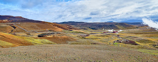
Mixed in with the black lava base were craggy black rocks of various heights amidst amazingly bright coloured flora which included mounds of moss and lichen and what appeared to be stunted birch bushes in addition to other low lying colourful leafy plants. 
At some places there was a fairly sharply defined edge of the flora and adjacent large areas which appeared to be completely devoid of the plants covering the terrain we were walking through.
This experience was a complete surprise and for me it was certainly one of the highlights of the day and possibly of the trip.
Michael just inside the cave.
When we reached the cave I found it interesting but a bit anti-climactic after the spectacular landscape we had just come through.
The cave might be familiar to those who follow The Game of Thrones, as some parts of that show were filmed here. Much of the upper portion is formed by huge rocks wedged at a variety of angles against each other leaving large open areas between the rocks. These allow quite a bit of light into the inner area which is partially filled with 45 degree water.  When the sun is shining, which it wasn’t, the effect of the sun entering through the open areas apparently provides interesting light inside the cave. According to the signs it was once a popular swimming area but swimming is no longer allowed.
I like the blurred image of Michael. Adds a bit of a (smiley) ghostly effect.
Volcano Hverfjall
We retraced our steps to return to the car then moved on to the volcano Hverfjall which you can see in the distance here.
This huge classic ring crater, dominates the lava fields on eastern side of Mývatn. The residual nearly symmetrical rim rises about 450 meters and is over 1 kilometer across!
The crater apparently appeared about 2700 years ago in a violent eruption.
What remains is composed of loose gravel seemingly barren of plant life though a closer look reveals scattered bits of vegetation which made me smile. It is indicative of the resilience of plant life capable of finding root in the seemingly hostile environment of this pile of gravel.
Travel books say that there is an easy trail up to the rim and, while the trail is not rugged, it is steep and long with the degree of incline increasing the closer you get to the top. In this photo you can, if you look closely at Hverfjall in the distance, get a glimpse of the trail up the side.
I have to say that I had to rest several times on the way to the top but, with encouragement, I did reach it!  I don’t think I was the only one taking a bit of a break now and then either. And we didn't notice other identifiable octogenarians among the climbers we saw.
To get the sense of height, note the vehicle on the road below
The view from the rim was quite stunning both inside the crater and in the panoramic perspective of the surrounding area outside including areas like Krafla that we had visited a day or so earlier.
The path down was much easier, from a cardiopulmonary stand point, than going up but presented its own challenges for knees and back along with the risk of falling as a result of losing one's balance on unstable rocks. I'm happy to say that I made the climb to the top and the walk down without incident.

Remember the geothermal power plant? See it over there?
It was here that I had my first encounter with an Iceland public restroom facility. The first surprise is that, in order to get in, you must pay 200 Krona. I happened to have the correct coin (not sure what one does if one is without cash) so inserted it and received a paper “receipt” which must be scanned to allow entry. What I didn’t expect was that I also needed that piece of paper to get out and I had tossed it into the trash. Fortunately, I am still flexible enough to climb over the obstructing rotating bar  - or in this case non rotating bar - in order to exit.

From here we drove to nearby Dimmuborgir (literally, Dark Castles) which, along with Grjótagja and the volcano, Hverfjall, where we had just visited, is part of the eastern Mývatn lakeside hike. We originally planned to hike to each of the places but it was a lot of ground to cover during the time available so driving seemed the better travel choice.
Dimmuborgir is a huge area of unusual large lava pillars and crags. It is believed to have been formed around 2000 years ago when a lake of lava from nearby volcanoes formed over a marsh or lake. It is said that hot lava heated the water to boiling pushing water through the molten lava and cooling it to form, over time, the pillars and varied forms of lava rock seen in this area today.
I have a lot of photos of this fascinating area but I think these two give a pretty good idea of what we saw there.

So, it is the end of our last day before the drive back to Keflavik airport and the 5 hour flight to Toronto.

And, as it was our last day, we decided to have dinner at the restaurant said by some locals to be the best restaurant in Akureyri.  And, it may well be the best as we found both the food and the ambiance to be excellent and the best we experienced in Akureyri!

Because of the long drive and the need to catch a flight, we passed many potentially excellent photo opportunities, giving in only once, on route to Keflavik.

Our drive to Keflavik took us through Borgarnes - remember Borgarnes? It’s the place where I left my Algarve baseball cap in the restaurant. In spite of the time pressure to get to the airport, Michael wheeled into the parking lot at the restaurant, I went in, retrieved my cap, and we drove on!

When we reached the rental car return at the Keflavik airport we found… well, that’s a story to be forgotten.

Finally, I must tell you that when I went through security at the airport, I forgot to pick up my computer from the little grey tray, so, sadly, left it in the Keflavik airport. But the story has a happy ending! The computer was recovered by the security folks and they returned it to me, safe and sound with all the photos that I have been able to include in these blog posts! My sincere thanks to those who secured my computer, packed it up and sent it to me. To them, I’m very grateful!


Friday, October 6, 2017

Thursday Sept 14 - Day 6


We decided that today would be a quiet one so we slept a bit late, luxuriated in the hot tub and, all in good time, prepared to drive into Akureyri for brunch, a stroll around town with intermittent shopping for gifts for ourselves :-) and, of course, others.

This will be a relatively short post because of the nature of the day and the fact that I have very few images to show. But, as I may have said before, don't forget to click on any images that are here if you would like to see a larger version.

I’m sorry to say that I have essentially no photos of the town of Akureyri. Not exactly sure how that happened as we were so impressed with this town and its Nordic tidy newness, interesting streets and shops, excellent restaurants and mostly very friendly people.

Here again, we found communicating very easy since, unlike those of us who speak no Icelandic, virtually all Icelanders with whom we needed or wanted to converse spoke English.

One of the interesting features of this town which soon became apparent while driving is the traffic lights, in particular the red light and what you see in the photo is representative of every traffic light we saw in Akureyri. Welcome to Akureyri!

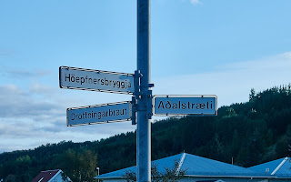
One other striking feature of travelling in Iceland is the nature of the Icelandic language with its. for us, large number of, and sometimes unrecognizable, letters in place names and street names. I found that, having difficulty spelling and pronouncing the names, it was almost impossible for me to remember them.


In addition to our shopping and strolling around the centre of town, we discovered and, two of us, spent a bit of time in a small but lovely Botanical Garden.

Later in the day just before going for dinner at Noa's seafood restaurant, we were down by the water (Akureyri is situated on the west side at the head of Eyjafjörður fjord which, at 60Km long, is the longest fjord in Iceland) where we spotted several swans, a fairly common sight on even small ponds in Iceland. They were quite far away so a challenge to photograph. Two of them (likely males) were squabbling, a bit of which you might be able to discern in this rather poor quality image.


Now, as you have no doubt recognized, 

I am really reaching here, especially for photos, but the only other image I have of Akureyri is a bit of it that lies across the fjord, so here is that photo below. And, actually, I'm not even sure that the location across the fjord is part of the town of Akureyri.


I don’t recall what we did that evening other than drive back to Hamragril with plans for a fairly busy day tomorrow.

Wednesday, October 4, 2017

Day five


We left late morning for a drive to some sites near Akureyri. The area in which we spent much of the time today and on day 7, was around Mývatn lake.  Mývatn is a shallow lake situated in an area of active volcanism just south of Akureyri and not far from the Krafla volcano. The lake and its surrounding wetlands have a rich fauna of waterbirds. Mývatn lake was created by a large basaltic lava eruption 2300 years ago, and the surrounding landscape is dominated by volcanic landforms, including lava pillars (which we will see later) and pseudocraters (also about which more later)

First to a falls, Goðafoss (foss means falls) - Waterfall of the Gods. To reach Goðafoss we took a small detour off the main road just south of lake Mývatn. 
Like Gullfoss, though neither as high nor tiered, this is a beautiful cascade of blue-green water tumbling over a broad expanse of the cliffs into the river below. 

Definitely worth the visit and the short walk down to the base of the falls. I’m including a few photos of these falls as I like them all and hope that you do as well.

From Goðafoss we continued on around the south portion of lake Mývatn to the town of Reykjahlið where we took a bit of time to review what we wanted to see here and how we would proceed.

We decided to go up to the Krafla area (Krafla is an 800 meter mountain but the entire area around including the geothermal power station is referred to as Krafla).

The area around the mountain is an active volcanic region where there is much steam pouring from numerous fumaroles. 

In the valley there is a geothermal power station which harnesses all this geothermal activity and sends it through an impressive collection of pipes snaking across the landscape into a complex distribution system. At some point these pipes go underground, surfacing again at intervals where there are small small concrete sheds, which we guess are maintenance and check point areas. 

At the top of what we assumed to be the mountain, Krafla,  there was  also a crater which turned out to be quite underwhelming though the view into the valley below was excellent.

Shortly we learned that, nearby, there is a crater, Leirhnjúkur, which is more impressive than the one on Krafla.   Getting to it involved a 3 or 4 Km (round trip) walk in sunny but quite cold, windy conditions through areas of bubbling, steaming mud pots. I had left my gloves in the car so my hands got sufficiently cold that using the camera was a bit difficult.
In the Krafla valley near a small hot pond.

According to one source, Leirhnjúkur originally appeared in 1727 as a lava fountain, spewing molten material for 2 years before becoming quiet. 
On the walk to Leirhnjúkur - note steam on the hillside.

In 1975 a small eruption in Leirhnjúkur led to the Krafla fires which apparently went on for nine years leaving the smouldering remnants seen today.
At the Leirhnjúkur site
In the photo above the closest two sulfurous steam plumes are the result of extremely hot water blasting out with extreme force from a pipe in the ground into the pond water. 


It is said that the earth’s crust is extremely thin here (photo left) so the surface is very hot which likely accounts for the steam rising from the rocks.
Steaming hot mud pond
Michael and Rod checking out the lava material in the crater wall.

This was an amazing site of a relatively recently erupted volcano with smouldering black lava rock strewn over a huge area.

The photos fail to show the extent of the area over which the extruded material travelled.
Hot mud pot.

From Leirhnjúkur and the cold walk back to the car we moved on to the warmth of the Myvatn nature baths in which we languished for over an hour. I didn’t realize it at the time but have since learned that this bath is not a natural bath but rather man made and heated by hot water from the nearby geothermal power station. Now, you may recall my comment about visiting Iceland being expensive - another example of this was the cost of the bath for three of us (two seniors fares) came to just under $200 CND! But as it included 2 beers we gave it not another thought and thoroughly enjoyed our hour or so in the luxurious warmth of the geothermally heated water.


Tomorrow we plan to spend time relaxing in the hot tub at “home” before going for lunch, shopping and just strolling around the lovely town of Akureyri.